-
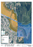
Appendix B: Application Area Maps
This document contains the aerial maps of the Wainuiomata River and areas included within the consent application.
alarm Published 06 Dec 2016 -
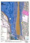
Appendix B: Application Area and Land Ownership
This document contains aerial maps of the areas within the resource consent application.
alarm Published 06 Dec 2016 -
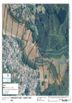
Appendix C: Land Ownership Maps
This document contains the aerial maps of land ownership within the area of the consent application.
alarm Published 06 Dec 2016 -
Appendix B: Application Area and Land Ownership
This document contains aerial maps of the areas within the resource consent application.
There is no digital version of this document available, but you can get in touch with publications@gw.govt.nz to get a copy of the document.
alarm Published 05 Dec 2016 -
-
-
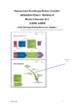
Ruamāhanga Whaitua Committee meeting/Monday 5 December 2016
WHEN: Monday 5 December 2016 12:00PM –6:00PM
WHERE: South Wairarapa Working Men’s Club, Greytown
alarm Published 05 Dec 2016 -
Environmental Monitoring Plan
This document contains the Environmental Monitoring Plan which proposes a programme of environmental monitoring which can be used as indicators of the effects of river management activities on selected environmental…
alarm Published 02 Dec 2016 -
Supplement to the Farm-Scale Modelling Report
Prepared for GWRC by T Parminter
alarm Published 01 Dec 2016 -
